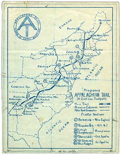
Trail Information
There are plenty of hiking trails in the area, including access to the Appalachian Trail just a couple miles up the road. Here's some basic nearby trail information if you'd like to take a hike!
Sams Gap Access Point is the closest accessible place on the Appalachian Trail to the Mars Hill area or the route on I-26 from Tennessee into North Carolina, and is just a couple miles up the Old Asheville Highway from us. It has one of the nicer parking areas for Trail access in Madison County. There is a nice hike for under 2 miles going south to High Rock for a good view. Going north toward Spivey Gap, Big Bald Mountain (6.5 miles) affords another spectacular 360-degree view from a high elevation. Big Bald is the highest elevation in Madison County at 5516'. From Sams Gap on the Appalachian Trail, Devils Fork Gap is 8.2 miles and Spivey Gap (in Tennessee) is 13.6 miles.
Sites on the Trail from Sams Gap:
- 2 miles hiking south to Devils Fork is High Rock which provides a good view when not overgrown with summer vegetation
- 6.5 miles hiking north to Spivey Gap is Big Bald Mountain where you have 360-degree views from an elevation of 5516' which is the highest in Madison County
Driving Directions to Parking:
GPS Location: N 35° 57.133' W 82° 33.652'
From Mars Hill: Take I-26 toward Tennessee to Exit 3. At the bottom of the ramp, turn right onto Bear Branch Road and then left onto NC Highway 23A. Stay on NC Highway 23A for 3.1 miles for Parking Access on the left side of the highway just before the I 26 overpass.
Hiking the Trail: To hike the trail north to Spivey Gap ( 13.6 miles), cross the highway to the gate for the Trail. This trail goes to Spivey Gap which is the next parking access point but is in Tennessee.
To hike the trail south to Devils Fork Gap (8.2 miles), walk under the I-26 overpass to the trail on the left side of the highway. Go up the road and look for the signs on the left side.
Appalachian Trail Access Points in Madison County, NC
Trail Section (going north)
Max Patch Road (NC 1182) to Lemon Gap (NC 1182/TN107) - 6.2 miles
One of the most beautiful spots in Madison County, a bald which offers spectacular 360-degree views on clear days.
- Good parking facilities
- Offers two short closed loop trails across the bald
- Nice hike north to Lemon Gap with little elevation change
Lemon Gap (NC 1182/TN 107P) to Garenflo Gap (Top of Gorenflo Gap Road) - 7.4 miles
Somewhat remote, although beautiful once you arrive at the parking area. For parking access, you have to travel on almost 4 miles more of gravel road beyond Max Patch.
- Nice hike south to Max Patch with little elevation change
- The hike north is the easiest way to Bluff Mountain which offers views when leaves are gone
Garenflo Gap (Top of Gorenflo Gap Road) to Town of Hot Springs - 6.6 miles
- Not too far of a drive from Hot Springs
- Only 1.6 miles off the main highway
- Hike south is somewhat strenuous but seeing the view from Bluff Mountain is worth it when leaves are gone
- Hike north to Hot Springs is quite scenic as you come down into the town and are overlooking the French Broad River
Town of Hot Springs to Tanyard Gap (US 25/70 by Mill Ridge) - 5.9 miles
- Easiest access in the whole county
- Trail runs right through the main street
- Restaurants and cabins are all right there -- plus a hot mineral springs spa
- Nice hike north goes to Lover's Leap Rock with a spectacular view of the French Broad River and the town
Tanyard Gap (US 25/70 by Mill Ridge) to Rich Mountain Fire Tower - 2.4 miles
- Parking is a short way off the main highway
- Nice hike either direction
- Rich Mountain Fire Tower is just 2.4 miles from here for a panoramic view (when open)
- Hiking south into Hot Springs is mostly downhill and the first mile is an old road
- Hiking north on the portion from Hurricane Gap toward Allen Gap is one of the prettiest stretches in the County, walking along the top of a ridge past large hardwoods without a strenuous path
Allen Gap (NC 208/TN 70) to Devils Fork Gap (NC 212) - 20.2 miles
- Limited parking and somewhat difficult to pull out from parking onto busy highway
- Hiking north has some interesting sites such as Viking Mountain (Camp Creek Bald), Shelton Graves and White Rock Cliffs
Devils Fork Gap (NC 212/TN 352) to Sams Gap (US 23A) - 8.2 miles
- Quite far to drive for parking access
- Hiking south will get you to White Rock Cliffs and Viking Mountain (Camp Creek Bald)
Sams Gap (US 23A) to Spivey Gap (US 19W) - 13.6 miles
- Closest to I-26 for Mars Hill and drive to Tennessee
- Good parking facilities
- Hiking south takes you to High Rock in just 1 mile for a good view
- Hiking north leads to spectacular 360-degree views from Big Bald Mountain